

The Coldest Vein
Inside the 1948 mission to map the invisible thermal architecture of the Labrador Current aboard H.M.C.S. Haida.

The North Atlantic does not give up its secrets willingly. For centuries it was a graveyard for wooden hulls and iron ambition, a place where the map ended and the ice began. By September 1948 the war was over, but the Canadian Navy had turned its attention to a different kind of adversary: the ocean itself.
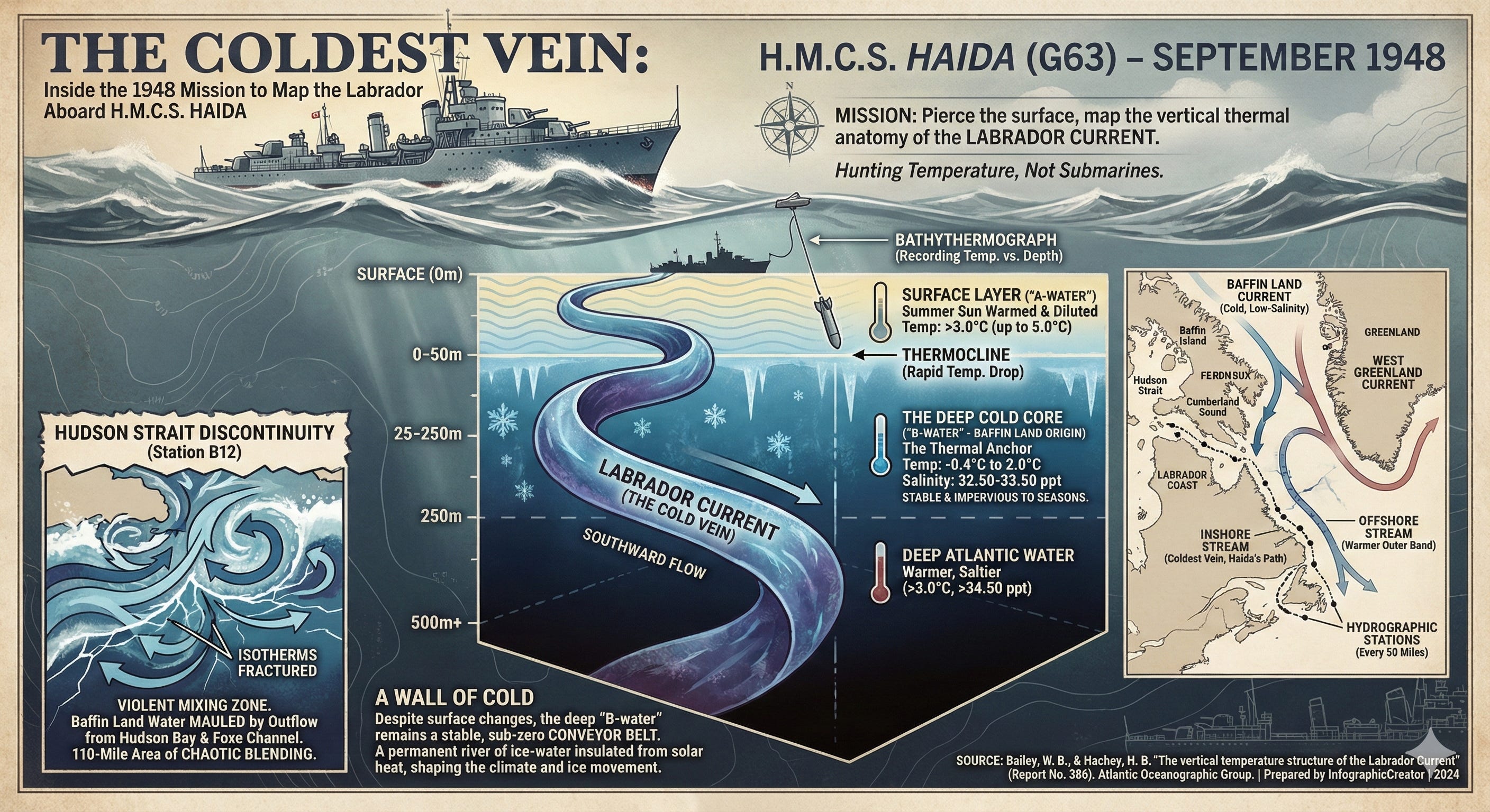
H.M.C.S. Haida, a destroyer destined for legendary status in Canadian naval history, was steaming north. Under the command of Lieutenant Commander Pickard, the vessel was cutting through the grey swells off the coast of Labrador. They were not hunting submarines or escorting convoys. They were hunting temperature.
Hidden beneath the surface chop lay the Labrador Current, a massive, sinuous river of cold water moving southward over the continental shelf. To the naked eye it was just dark water. To the oceanographers of the Atlantic Oceanographic Group, it was a complex thermodynamic structure that controlled the climate, the ice, and the movement of fleets. The mission was to pierce the surface and map the vertical anatomy of the current, plunging instruments hundreds of meters down to find where the freezing water from Baffin Island met the warmer currents of the Atlantic.
A History Written in Ice
The curiosity regarding this stretch of ocean predated the Dominion of Canada by nearly seven hundred years. The archives of exploration trace the first written accounts of the region to 1266, detailing a Norse expedition that pushed into the icy jaws of Smith Sound. Three centuries later, in 1576, Martin Frobisher made the first recorded crossing of the Labrador Sea, battling the same elemental forces that Haida now faced.
For generations, however, knowledge remained surface-level. Mariners knew the water was cold and the ice treacherous, but they did not understand the mechanics of the flow. It was not until the “Chance” expedition of 1926 that scientists attempted to strip away the mystery and analyze the physical and chemical structure of the current. This was followed by the persistent work of the United States Coast Guard expeditions “Marion” and “General Greene” between 1928 and 1935, which began to sketch the rough outlines of this thermal highway.
By 1948, the technology had evolved. The Haida was equipped with bathythermographs, instruments capable of recording a continuous profile of temperature against depth. This allowed the scientists to see the “fine structure” of the ocean—the sudden drops, the isothermal layers, and the hidden tongues of arctic water that defied the surface warmth. As Haida moved north toward Hudson Strait, stopping at ten hydrographic stations and taking readings every fifty miles, she was compiling a dossier on the invisible fluid dynamics that shaped the eastern coast of the continent.
The Architecture of the Deep
The Labrador Current is not a single monolithic block of water. It is a binary system, a marriage of two distinct flows born in the arctic north. The investigations revealed that the current originates near Cumberland Sound, where the frigid Baffin Land Current collides and merges with the relatively warmer West Greenland Current.
As these waters flow south, they split. An inshore stream, heavy with the cold, low-salinity blood of the arctic, hugs the continental shelf. It pushes into Hudson Strait, recurves at Big Island, and flows out past Cape Chidley, picking up the discharge from Hudson Bay. Further out, over the continental slope, flows the offshore stream. This outer band carries the memory of the West Greenland current, warmer and saltier, pressing against the cold inner wall but rarely breaching it.
The data brought back by Haida painted a stark picture of this division. The scientists identified two primary water masses. The first, labeled “A-water,” was coastal in nature. It occupied the upper fifty meters, warmed by the summer sun to temperatures above 3.0°C and diluted by land drainage. But beneath this thin skin of summer lay the “B-water.”
This was the true spine of the Labrador Current. Between depths of 25 and 250 meters, the water temperature plummeted. The thermometers registered a harsh stability, with readings ranging from 2.0°C down to a freezing -0.4°C. The salinity held steady between 32.50 and 33.50 parts per thousand. This was Baffin Land water, a sub-zero conveyor belt moving relentlessly south, insulated from the sun by the stable layers above it.
The Hudson Strait Discontinuity
As Haida approached the mouth of Hudson Strait, the orderly stratification of the ocean began to break down. The bathythermograph traces, which had shown neat layers of temperature further south, suddenly became erratic. The isotherms—lines connecting points of equal temperature—fractured.
This was the signature of violence. In the vicinity of Station B12, the sensors detected an area of intense mixing extending over 110 miles. Here, the waters of the Baffin Land current were being mauled by the outflow from Hudson Bay and Foxe Channel. The sheer volume of water moving through this chokepoint created a chaotic blending zone, creating what the scientists termed “Labrador coastal water.”
The forensic analysis of the temperature and salinity curves revealed a critical detail about Haida’s path. The ship had tracked almost exclusively through the cold vein of the Baffin Land water. The warmer, saltier West Greenland water—which typically exhibits temperatures as high as 3.8°C and salinities of 34.60—was nowhere to be found in their samples. The destroyer had hugged the axis of the cold current, effectively riding the freezing inner lane of the oceanic highway.
A Wall of Cold
The data collected during that September cruise offered a final, chilling conclusion about the stability of the northern seas. Despite the mixing at the surface, where autumnal cooling was already beginning to churn the upper layers, the deep structure of the Labrador Current remained remarkably consistent.
The “B-water” acted as a thermal anchor. While the surface might warm to 5.0°C in the late summer or freeze solid in the winter, the massive body of water beneath—that great volume of liquid moving between -0.5°C and 1.0°C—was impervious to the seasons. It was a cold, dense wall that prevented solar heat from penetrating the depths.
The Haida returned to port having confirmed that the Labrador Current was not merely a surface phenomenon. It was a deep, stable, and powerful force of nature. The charts drawn from her voyage showed tongues of cold water protruding like daggers into the section, vestiges of the arctic winter persisting through the summer. In the grand interplay of ocean and atmosphere, the current was a constant, a permanent river of ice-water flowing past the doorstep of the Atlantic provinces.
Source Documents
Bailey, W. B., & Hachey, H. B. (n.d.). The vertical temperature structure of the Labrador Current (Report No. 386). Atlantic Oceanographic Group.