

The Silent Watch on the US-Canada Border
Inside the relentless physical struggle to maintain the longest undefended boundary in the world against the forces of nature.

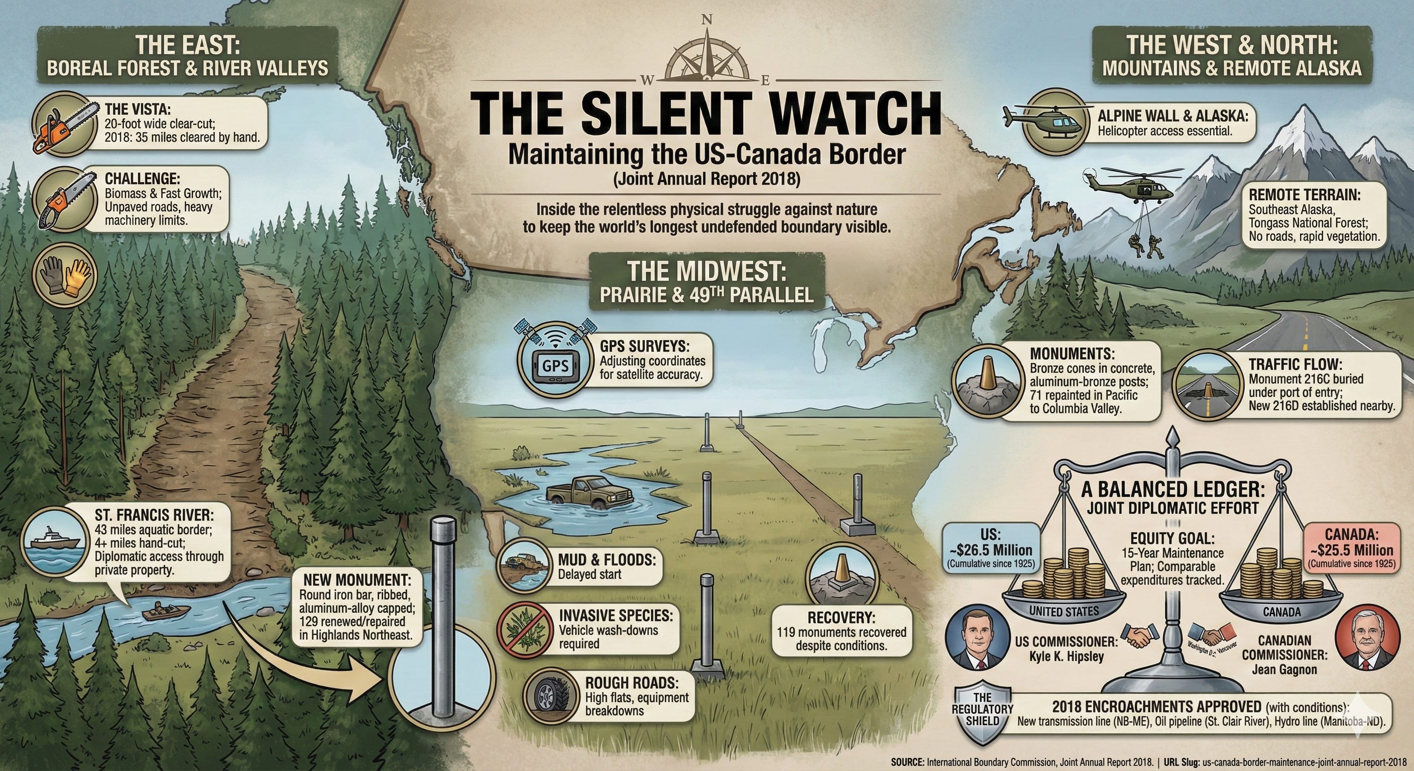
Deep in the boreal forests where Maine meets New Brunswick, a twenty-foot wide scar slices through the wilderness. It is a straight line of negative space that refuses to acknowledge the chaotic growth of nature. This is the Vista. It stretches toward the horizon, climbing hills and plunging into swamps, marking the exact division of sovereignty between two massive nations. While the world often fixates on walls and patrols, the US-Canada border is defined by something far quieter but equally demanding. It is defined by a relentless, century-old battle against the encroaching forest.
The upkeep of this boundary is not a matter of high-tech surveillance or militarized zones. It is a matter of chainsaws, paint, and geodetic science. In 2018, the International Boundary Commission, a joint organization born from the Treaty of 1925, continued its quiet mandate to keep the line visible. Without this maintenance, the longest undefended border in the world would simply disappear. The forest would reclaim the Vista, the monuments would sink into the mud, and the precise geometric definition of where one country ends and the other begins would vanish into the underbrush.
The Slash Through the Wilderness
The concept of the boundary is theoretical, but the execution is brutally physical. The Commission divides the border into distinct sections, each presenting unique hostile terrains. In the East, the North Line runs for seventy-eight miles from the source of the St. Croix River to the St. John River. Here, the challenge is biomass. The vegetation grows with aggressive speed.
In 2018, crews descended upon a thirty-five-mile stretch of this line. Their objective was clear. They needed to ensure an unobstructed line of sight. This meant hand-clearing overhanging branches, felling trees, and stripping away shrubs to maintain that critical twenty-foot corridor. The work is repetitive and exhausting. It requires navigating unpaved logging roads and trekking through dense growth where heavy machinery cannot reach.
Further north, along the St. Francis River, the boundary becomes aquatic, yet the vegetation on the banks still demands attention. For forty-three miles, dense woods border the American side, while low-lying farmland lines the Canadian shore. It had been five years since the last cut. Substantial trees—fir, poplar, and spruce—had risen to obscure the line. The crews moved in with brush saws, cutting over four miles by hand. They also had to act as diplomats. Because the border often runs through backyards and farms, the field crews had to communicate with property owners to access the river, ensuring that the only sign of their passing was a renewed monument and a cleared view.
Iron Bars and Buried History
The boundary is anchored by monuments. These are not merely symbolic statues but precise geodetic reference points. Over a century of freeze-thaw cycles, floods, and agricultural development takes a toll on these markers. The Commission’s work involves a constant cycle of inspection, repair, and replacement.
On the Highlands Northeast Section, a rugged and difficult stretch between Maine and Quebec, the inspectors found significant deterioration. The old century-era rock posts were failing. To combat this, the Commission deployed a new type of monument in 2018. They utilized a round iron bar, ribbed like construction reinforcing steel, capped with a forged aluminum alloy. These materials are designed to survive where stone cracks and crumbles.
The installation of these markers is a feat of logistics. In areas where the bedrock lay exposed or just below the surface, crews had to drive the bars into the earth, sometimes achieving depths of thirty inches, other times hitting resistance at just six inches. In total, one hundred and twenty-nine monuments were renewed or repaired in this section alone.
This work often intersects with daily life in unexpected ways. Along the St. John River, reference monuments sit on the manicured lawns of private citizens. Field crews spent weeks coordinating with residents, determining where they could drive their trucks to avoid ruining property. The goal was invisibility. They wanted to leave behind nothing but a freshly painted monument, gleaming white against the green grass.
Battlegrounds of Mud and Iron
West of the Great Lakes, the terrain shifts. The dense forests give way to the vast, exposing expanse of the prairies. Here, along the 49th Parallel separating North Dakota form Manitoba, the Commission faced a different adversary: the oil boom. For years, intense industrial activity and the resulting infrastructure made accessing certain sections of the border nearly impossible. In 2018, a window opened.
A team moved into the gap between Monuments 621 and 697. This was a critical missing piece in the data. They needed to conduct GPS surveys to adjust the coordinates of the monuments, ensuring modern satellite accuracy matched the physical markers on the ground. However, the geography fought back. Heavy rains turned the plains into a mire. The area was in flood stage, forcing the crews to delay their start and revise their plans while waiting for the lower lands to drain.
When the waters receded, a new threat emerged. A stakeholder informed the crew of a noxious weed infestation in the area. This seemingly minor biological hazard had major logistical implications. To prevent spreading the invasive species across the continent, the crews had to wash down every vehicle, trailer, and ATV before moving between locations.
The physical toll on the equipment was immense. The rough, unmaintained roads along the 49th Parallel shredded tires. The crew dealt with a particularly high number of flats, and their Diesel Mule utility vehicle suffered multiple breakdowns that ate into their schedule. Despite the mud, the weeds, and the mechanical failures, they managed to recover one hundred and nineteen monuments, closing the data gap that had plagued the section.
Moving the Line of Traffic
The border is static, but the world around it moves. At the Kingsgate-Eastport Port of Entry, where British Columbia meets Idaho, the infrastructure of commerce clashed with the history of the boundary. The Port of Entry supervisor had a problem. Monument 216C was sitting directly in the line of traffic. It was a hazard to the vehicles flowing between the two nations.
The Commission had to intervene. They could not simply remove the boundary marker, but they could adapt it. In the previous season, they had removed the above-ground structure of the monument. In 2018, they returned to finish the job. They maintained the position of the monument buried two feet beneath the heavy asphalt, preserving the geodetic truth of the border while clearing the surface for trade. To replace the visual marker, they established a new monument, 216D, in a safer location nearby, installing a pebble roadside monument on a base set the year prior. It was a small adjustment in coordinates, but a significant nod to the reality that the border must coexist with the civilization it divides.
The Alpine Wall
As the border moves west, it climbs. The 49th Parallel hits the Rockies and the terrain becomes vertical. This is the realm of the Pacific to Columbia Valley section. Here, the boundary intervenes between laborious American and Canadian communities that maintain close relationships. The visibility of the line is crucial in these high-traffic corridors.
The Commission focused on densification. They inspected seventy-three monuments, repainting seventy-one of them to ensure they stood out against the landscape. But the true test of the Commission’s reach lay further north, in the detached majesty of Southeast Alaska.
The boundary between Alaska and British Columbia is a jagged line running through some of the most remote and unforgiving territory on the continent. It abuts the Tongass National Forest and the Stikine-LeConte Wilderness Area. There are no roads here. There are no manicured lawns.
To clear the vista in this sector, the Commission contracted work for three zones totaling nearly fifteen miles. The vegetation here does not just grow; it erupts. The crews had to clear a corridor through the Katete River Valley and the Stikine River Valley. The monuments they were uncovering were bronze cones filled with concrete, set in square bases, or simple aluminum-bronze posts drilled into rock. Access was impossible by land. The entire operation required helicopter support to drop crews and gear into the wilderness. They worked in isolation, cutting a line through a landscape that has barely changed since the treaties were signed.
A Balanced Ledger
The operation of the International Boundary Commission is a study in diplomatic symmetry. It is organized into two sections, United States and Canada, each with its own Commissioner, staff, and budget. The maintenance work is shared equitably, dictated by a long-term fifteen-year plan that ensures no mile of the boundary is neglected for too long.
The financial breakdown of this maintenance reflects the partnership. The Commission tracks “comparable expenditures” to demonstrate that the burden is shared. By March 31, 2018, the cumulative total spent since 1925 showed the United States at roughly 26.5 million dollars and Canada at 25.5 million dollars. While there is often a slight lag in expenditures due to differing budget cycles, the goal remains a perfect balance.
The Commissioners, Kyle K. Hipsley for the United States and Jean Gagnon for Canada, met twice in 2018. They met once in Washington, D.C., and once in Vancouver. Their role is to oversee the abstractions of the budget and the realities of the field. They conducted inspections personally, traveling to the West Line to look at line houses and rivers, and visiting the field parties on the 49th Parallel. They stood at Monument 178, where the St. Francis River meets the Southwest Line, witnessing the physical convergence of the abstract lines they are sworn to uphold.
The Regulatory Shield
The Commission does more than cut trees and pour concrete. It acts as a regulatory gatekeeper. The treaty mandates that no construction can occur within ten feet of the boundary without authorization. This ten-foot buffer is a sacrosanct zone of neutrality.
In 2018, the Commissioners processed multiple applications for encroachment. They granted permission for a new transmission line near Woodstock, New Brunswick, to cross the border and tie into the grid in Houlton, Maine. They allowed an underground oil pipeline to cross the St. Clair River. They permitted Manitoba Hydro to string an alternating current transmission line across the 49th Parallel.
Each of these approvals requires a verification that the construction will not obscure or threaten the boundary. It is a bureaucratic layer that ensures the border remains sovereign, preventing the gradual creep of infrastructure from erasing the line.
The Unending Cycle
The work is never finished. As soon as a vista is cleared, the saplings begin to rise. As soon as a monument is painted, the weather begins to strip it away. The 2018 report concludes with a plan for 2019, outlining the next phase of the cycle. The US Section would take responsibility for the south half of the North Line and the St. Francis River. The Canadian Section would tackle Halls Stream and the St. Lawrence River.
The border is often discussed in terms of politics, economics, and security. It is debated in parliaments and congresses. But for the International Boundary Commission, the border is dirt, rock, water, and wood. It is a physical reality that requires sweat and diesel to maintain.
From the mosquito-choked swamps of Maine to the vertiginous peaks of Alaska, the “Silent Watch” continues. The vistas are kept open, not just for the sake of a treaty, but as a visible testament to a peaceful division of the continent. The trees are cut, the iron is set, and the line remains.
Source Documents
International Boundary Commission. (2018). Joint Annual Report 2018.
What an excellent article. We don't think about the physical work, dangers, and hardships in maintaining a border. I have a new appreciation for all of that; thanks.