

The Lake Always Wins
A 1989 federal report said stop fighting Erie’s erosion at Point Pelee. The radical fix: give the land back to the marsh.

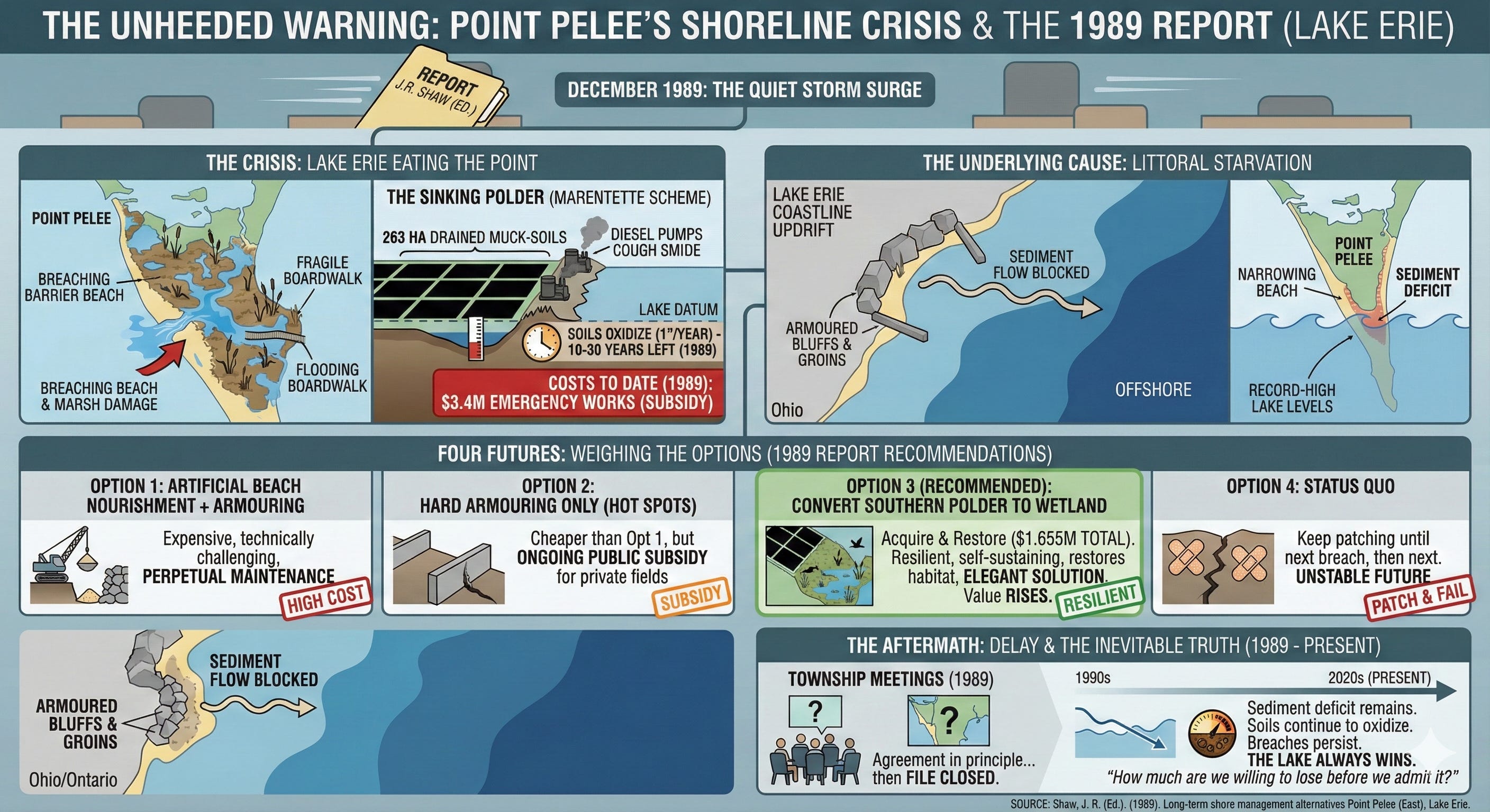
In December 1989, a slim government report slid across desks in Burlington, Ottawa, and Point Pelee National Park with the quiet force of a storm surge that had been building for fifteen years.
Lake Erie was not merely rising and falling with its usual moods.
It was eating the point itself.
The narrow barrier beach on the east side of the park — the one thing standing between the open lake and Canada’s largest remaining freshwater marsh — had begun to breach so often that park staff treated it as routine.
Every storm rewrote the shoreline a little farther inland.
Every breach pushed lake water deeper into the marsh, shifting its chemistry, killing cattails, opening channels for carp, and threatening the fragile boardwalk where thousands of birders stood each spring.
North of the park boundary, the view from the air looked even worse.
263 hectares of black, drained muck-soils — the Marentette Drainage Scheme — lay barely a metre above the lake datum, held back by a ragged line of earthen dykes and diesel pumps that coughed around the clock.
By 1989 taxpayers had already paid $3.4 million in emergency works to keep those fields dry.
And the fields were still sinking, because drained organic soils oxidize and disappear at roughly an inch a year.
Ten to thirty years left, the engineers said.
After that, the land would be lake bottom whether anyone liked it or not.
The report, edited by J.R. Shaw at the Bayfield Institute, did something almost unheard of in Canadian shore-protection circles: it ran the numbers without delusion.
Structural fixes were costed, structural fixes were damned, and one non-structural option was lifted above the rest like a flare over black water.
A Thin Red Line on the Map
Look at the 1976 aerial photograph on page iii of the report.
A delicate arrowhead of sand and marsh points south into the lake like a compass needle.
The east beach is a bright, almost white ribbon.
Behind it, the marsh is a dark, living sponge.
North of the park boundary a perfect grid of drainage ditches cuts the black square of the Marentette polder.
The north-south dyke runs straight as a ruler for two kilometres, then kicks ninety degrees east, forming an L that looks, from 50,000 feet, like a desperate attempt to hold the lake in a corner.
By the late 1980s that L was cracking.
Wave scars climbed the outside face of the north-south dyke like claw marks.
The east-west leg had already been overtopped several times.
Each high-water year shoved the breach points a little farther north, a little closer to the pumps that kept the polder habitable.
The cause was textbook littoral starvation.
Groins and revetments built updrift (mostly in Ohio, some in Ontario) had starved the longshore current of sand.
The same bluffs that once fed Point Pelee had been armoured decades earlier.
What little sediment still moved now bypassed the point entirely or dropped into deep water offshore.
Add record-high lake levels through the 1980s and the beach simply ran out of material to replace what the waves took.
Result: the beach narrowed, flattened, and finally vanished in storms, turning the park’s marsh into an accidental lagoon open to the lake.
The $3.4 Million Question
Southwestern Ontario had seen this movie before.
In the early 1970s, federal-provincial reviews of other dyking schemes — Long Point, Hillman Marsh, Rondeau — had all reached the same brutal conclusion: the costs of keeping Great Lakes water out of drained agricultural polders almost certainly exceeded the value of the crops grown inside them.
Yet when the water came to Point Pelee, the reflex was the same: build higher, build faster, send the bill to Ottawa.
By 1989 the tab was $3.4 million and climbing, and the dykes were still only “emergency” works — temporary patches on a permanent problem.
The report laid the receipts on the table and asked the question no one in the room wanted to say aloud:
How much more are we willing to spend to delay an outcome that is already written in the stratigraphy?
Four Futures, One Recommendation
The Technical Review Committee weighed four long-term alternatives, each sized to last only the remaining 10–30-year life of the drained soils.
Option 1
Artificial beach nourishment in the northeast corner of the park plus rock armouring at the south end of the north-south dyke.
Expensive, technically challenging, and still required perpetual maintenance.
Option 2
Hard armouring of the worst erosion hot spots on both legs of the dyke system, no attempt to save the park beach.
Cheaper than Option 1, but still required ongoing public subsidy for private fields.
Option 3
Do nothing to the park beach, let nature take the shoreline where it will, and convert the most threatened portion of the polder — the southern 83 hectares (206 acres) — back into marsh.
Cost: $1.03 million acquisition + $625,000 for dyke modifications, road raises, and water-control structures.
Total ≈ $1.655 million.
Option 4
Status quo — keep patching until the next breach, then the next, then the next.
The committee’s recommendation was unambiguous.
Convert the southern polder to wetland.
It was the only option entirely compatible with both flooding and shoreline recession.
It was the only option that ended the permanent public subsidy of private agricultural benefit.
It was the only option whose value would rise over time as agricultural value collapsed.
And it was the only option that turned a liability into an asset: restored marsh, expanded habitat, restored hydrological connection between the park and the lake — exactly what the park needed to heal its breached beach.
In short, the cheapest, most resilient, most elegant solution was to stop calling the land “farmland” and start calling it “future marsh.”
The Township Meetings No One Remembers
April 11, 1989.
Mersea Township hall.
Landowners, drainage commissioners, park staff, provincial and federal officials packed into folding chairs under flickering fluorescents.
The project coordinator stood at the map and pointed to the red polygon on the south polder.
“This area,” he said, “is going to be lake eventually.
The question is whether we spend another ten million pretending it isn’t, or we spend one-point-six and get a marsh that is worth more wet than it ever was dry.”
Silence, then the kind of questions that come when people realize the ground under their boots is negotiable.
Seven months later, November 16, 1989 — another meeting, same room, different mood.
The township agreed in principle to the feasibility study, provided Ottawa could find the money through the Inland Waters Directorate.
The report was circulated for comment.
Then the file closed.
Thirty-Six Years Later
The 1989 report never became policy, or it became policy too slowly to notice.
Lake levels fell in the 1990s, memories shortened, budgets tightened, and the dykes got another few rounds of emergency repairs.
But the sediment deficit never reversed.
The bluffs never started eroding again.
The groins updrift never came down.
The soils kept oxidizing.
Today, in the third decade of the twenty-first century, the east beach of Point Pelee is still breaching in big storms, the marsh is still changing, and the pumps in the Marentette polder still run — for now.
The 1989 report sits in a government repository, warning in plain bureaucratic prose what poets and coastal engineers have always known:
The lake always wins.
The only question is how much we are willing to lose before we admit it.
Source Documents
Shaw, J. R. (Ed.). (1989). Long-term shore management alternatives Point Pelee (East), Lake Erie (Canadian Manuscript Report of Fisheries and Aquatic Sciences No. 2039). Bayfield Institute, Department of Fisheries and Oceans Canada.