

The Secret History of Nova Scotia Earthquakes
A deep dive into colonial archives reveals tsunamis, meteor strikes, and forgotten tremors in a region once thought geologically silent.

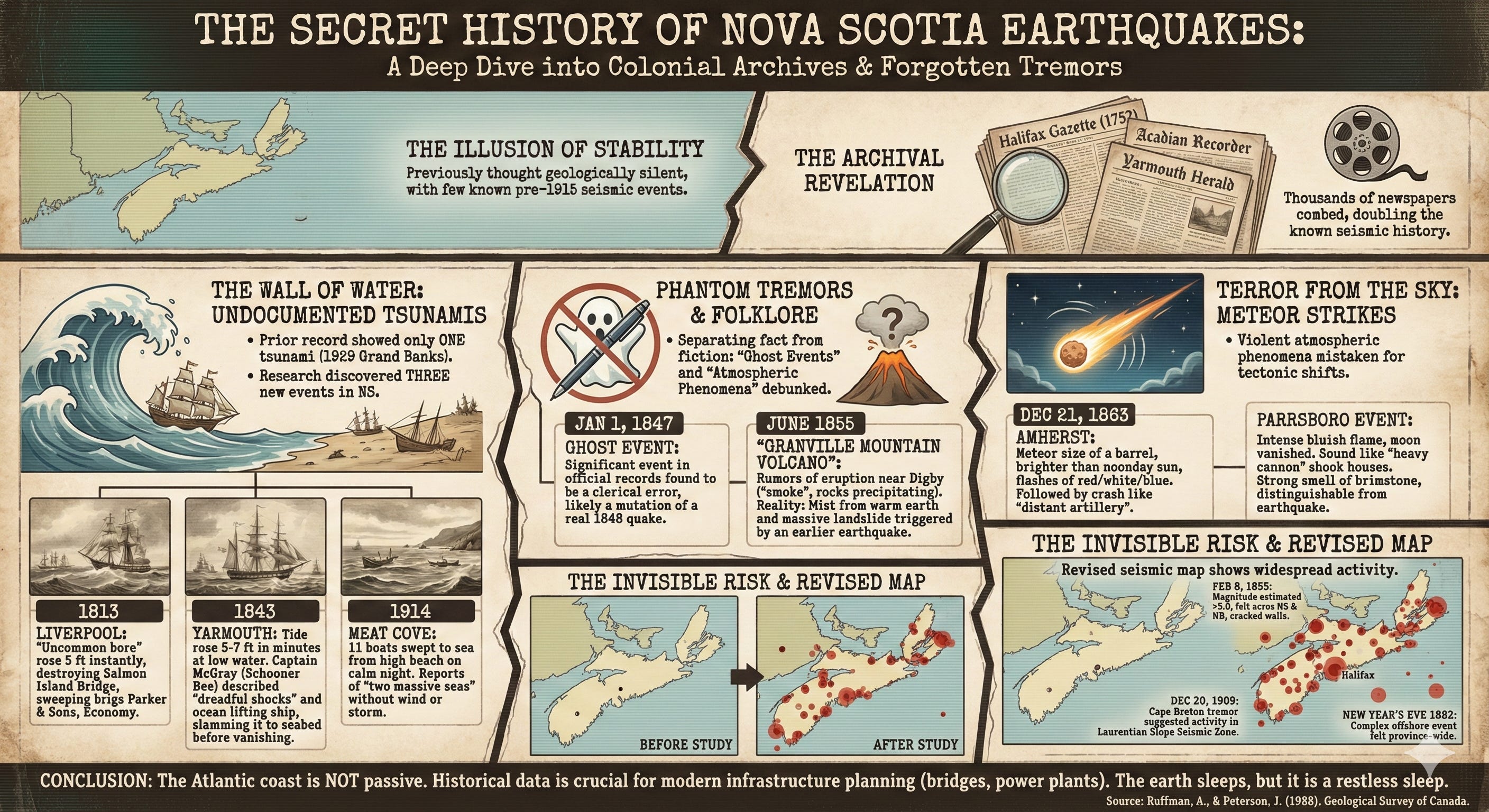
The microfilm reader hums in the quiet sterility of the archives. It is a sound far removed from the roar of a collapsing cliffside or the terrifying groan of a ship bottoming out in deep water. Yet within the reels of the Halifax Gazette and the Acadian Recorder lies the evidence of a geological violence that history had all but erased. We tend to think of the Atlantic coast as a passive margin. It is a place of ancient, settled rock, far removed from the volatile fault lines of California or the Pacific Rim. But a meticulous investigation into Nova Scotia earthquakes challenges that assumption of stability. By combing through thousands of brittle newspapers dating back to 1752, researchers have uncovered a lost history of seismic fury.
The ground beneath the Maritime provinces has not always been still. It has buckled, shaken, and roared with enough force to crack stone walls and send terrified residents running into the snow. The ocean has withdrawn and returned as a wall of water, smashing vessels against the shore. Meteors have screamed through the atmosphere with such sonic power they were mistaken for tectonic shifts. This narrative is not based on modern seismographs or digital sensors. It is built on the ink-stained testimony of sea captains, farmers, and terrified diarists who witnessed the earth rebel beneath their feet.
The Illusion of Stability
For decades, the seismic record of Eastern Canada was a patchy thing. Scientists knew about the devastating Grand Banks earthquake of 1929, a magnitude 7.2 event that sent a tsunami crashing into the Burin Peninsula of Newfoundland. That tragedy killed twenty-eight people and reshaped the understanding of Atlantic geology. But what came before? The sensitive instruments required to detect smaller tremors were not installed in Halifax until 1915. Before that, the record was dark.
This gap in data presented a dangerous blind spot. If you are building a nuclear power plant, a tidal energy barrier, or a massive bridge, you cannot rely solely on fifty years of data. You need to know what the earth is capable of over centuries. To fill this void, the Geological Survey of Canada commissioned a different kind of excavation. Instead of digging into the soil, researchers Alan Ruffman and Jean Peterson dug into the paper trail. They examined runs of newspapers from 1752 to 1867, looking for the telltale keywords that would indicate the earth had moved.
The results were staggering. Prior to this investigation, only thirteen earthquakes were known to have occurred in Nova Scotia before 1916. By the time the microfilm readers were turned off, the researchers had identified fourteen new, previously undocumented earthquakes within the province. They found evidence of thirty-three new events outside Nova Scotia, in New Brunswick, Quebec, and New England. They essentially doubled the known seismic history of the region. But they did more than just count tremors. They uncovered stories of near-misses and atmospheric phenomena that read like maritime thrillers.
The Phantom Tremors
One of the most critical tasks in historical seismology is separating fact from folklore. In the panicked correspondence of the nineteenth century, a landslide could become a volcano, and a frost quake could become a tectonic event. The researchers found themselves acting as ghost hunters, exorcising non-existent earthquakes from the official record.
For years, the Canadian Earthquake Epicentre File listed a significant seismic event on January 1, 1847. It was a “ghost event.” The researchers found absolutely no record of it in the local papers. It was likely a clerical error that had mutated into scientific fact, a phantom born from the confusion surrounding a real earthquake that happened a year later in 1848.
Then there was the case of the Granville Mountain Volcano. In June 1855, rumors swirled that a volcano had erupted near Digby. Reports described smoke, a chasm opening in the earth, and rocks precipitating down the hill with such velocity they penetrated the side of a cottage. It sounded apocalyptic. However, a careful reading of the Saint John Morning News and the Pictou Eastern Chronicle revealed the truth. The “smoke” was likely mist or water vapor rising from the warm earth in cold air. The “eruption” was a massive landslide, likely triggered by soil liquefaction from a genuine earthquake that had occurred months earlier in February. The newspapers of the day eventually concluded it was a landslide, but the legend of the Nova Scotia volcano persisted in the seismic catalogues until this investigation set the record straight.
The Wall of Water
Perhaps the most chilling discoveries in the archives were not the earthquakes themselves, but the water that followed them. Before this study, the historical record showed only three tsunamis affecting Atlantic Canada, with the 1929 Grand Banks disaster being the only one known to have hit Nova Scotia. The archival search rewrote that history, documenting three entirely new tsunamis that struck the province’s shores.
The first occurred on a winter morning in 1813. In Liverpool, Nova Scotia, the weather had been violent, with thunder and hail giving way to an eerie calm. Suddenly, at half-past eleven, an “uncommon bore” or influx of the sea rose five feet in an instant. It rushed up the harbor with terrifying speed. The brig Parker & Sons and the prize brig Economy were swept from their moorings. The schooner Polly had her stern stoved in. Upstream, the ice was lifted by the surge and smashed through the Salmon Island Bridge, destroying it. Just as quickly, the water receded, dragging vessels seaward over the bar. Local historian Thomas Haliburton noted a rumbling noise heard shortly before the wave, attributing the chaos to the shock of an earthquake.
Thirty years later, the sea attacked again. On April 18, 1843, the waters of Yarmouth Harbour suddenly went mad. At low water, just before dusk, the tide rushed in, rising from five to seven feet in minutes. It tore small craft from their anchors and then receded with equal violence, leaving the mudflats bare. At Bunker’s Island and the Cove, the water rose ten feet.
The most visceral account of this event came from Captain Bradford McGray, who was aboard the schooner Bee. They were entering Cook’s Harbour when the vessel was struck by “dreadful shocks.” The crew, terrified, struggled to keep their footing on the deck. Then came the sound. McGray described a loud roaring of the tide coming in. The ocean lifted the heavy vessel and slammed it down repeatedly against the bottom, splitting the keel and rudder. Then the water vanished, leaving the Bee high and dry at the top of the beach. For the crew standing on the damp sand, looking at their broken ship, it was a brush with mortality delivered by a smooth, windless sea.
Terror from the Sky
Not every rumble in the night came from below. The researchers found instances where the sky itself seemed to be falling, creating phenomena so violent they were categorized as earthquakes by the people who lived through them. These “meteorite terminations” provide a glimpse into the awe and terror of rural life in the nineteenth century.
On the night of December 21, 1863, the village of Amherst was illuminated by a light brighter than the noonday sun. A meteor, described as the size of a barrel, crossed the zenith from south to north. It burned for three seconds, painting the snow-covered landscape in flashes of red, white, and blue. Minutes later, the sound arrived. It was a crash like distant artillery or the rolling of heavy carriages over a bridge.
In Parrsboro, the experience was even more intense. The sky was overspread with a bluish flame so bright the moon vanished. Then came the report, sounding like a heavy cannon. It shook houses violently, waking residents from their sleep. A strong smell of brimstone pervaded the atmosphere, choking the villagers. The sensation was indistinguishable from an earthquake, yet the cause was extraterrestrial. By disentangling these cosmic impacts from tectonic events, the researchers ensured that the seismic hazard maps of the future would not be skewed by visitors from space.
The Midnight Shocks
The investigation also shed new light on the seismic activity of Cape Breton Island. On December 20, 1909, a tremor rippled through the northern peninsula. Communications with Inverness were cut off, leading to anxiety in Sydney that the town had been devastated. The telephone operator in Baddeck reported the town rocking. In Orangedale, dishes danced on shelves.
This event highlighted the difficulty of pinning down exact dates in historical research. Newspapers dated the event to “yesterday,” but publication schedules varied. Some accounts said Sunday, others Monday. It took a cross-reference with a report from the Antigonish Casket, identifying the event as occurring on Monday, to finally set the calendar straight. This tremor was significant because it suggested activity in the Laurentian Slope Seismic Zone, a deep-water fault system that remains a subject of intense study today.
Another tremor in 1914 revealed a bizarre phenomenon in northern Cape Breton. Fishermen at Meat Cove had hauled their boats high up the beach for the night. The weather was calm. Yet, the next morning, eleven boats were gone, swept out to sea. Marks on the beach showed the tide had risen far above the normal high-water mark. A man near Bay St. Lawrence reported seeing two massive seas rushing onshore around eleven at night. There was no storm, no wind. Just a silent, deadly rise of the ocean, likely caused by a submarine slump or a distant earthquake.
The Invisible Risk
The value of this historical detective work lies in the revised picture of risk it presents. Before this study, the seismic map of Nova Scotia was largely blank, save for a few anecdotal reports. Now, the map is dotted with epicenters. The researchers documented felt reports from Halifax to Sydney, from Yarmouth to the Annapolis Valley.
They found that the earthquake of February 8, 1855, was far more powerful than previously believed. Felt from Halifax to New Brunswick, it cracked walls and launched sleepers from their beds. In Moncton, it damaged a brick building. By analyzing the sheer size of the felt area, modern seismologists can estimate the magnitude at over 5.0.
Similarly, the investigation into the New Year’s Eve earthquake of 1882 revealed a complex event. Captain Samuel Trott, sitting in his study in Halifax, timed the shocks with the precision of a navigator. He noted the first heavy vibration at 10:07 p.m. and a second, lighter shock at 10:43 p.m. The plaster in his ceiling cracked in the direction of the noise. Reports flooded in from across the province, from Truro to Meteghan. The widespread nature of the reports suggests a major offshore event, possibly on the Scotian Shelf, a location that has implications for modern offshore energy exploration.
The Ongoing Tremor
The dusty pages of the Royal Gazette and the Yarmouth Herald have spoken. They tell us that the stability of the Atlantic coast is a relative term. The earth moves here. It generates tsunamis that can crush ships and scour harbours. It produces tremors strong enough to topple chimneys and crack masonry.
This reclaimed history serves as a warning. We build our cities, our power plants, and our bridges based on the probabilities of the past. By ignoring the pre-instrumental record, we were gambling with incomplete odds. The work of Ruffman and Peterson closed a gap in our collective memory. It proved that while the intervals between major events may be long, they are not infinite. The ground beneath Nova Scotia sleeps, but it is a restless sleep, punctuated by waking nightmares that we would do well to remember.
Source Documents
Ruffman, A., & Peterson, J. (1988). Pre-Confederation historical seismicity of Nova Scotia with an examination of selected later events. Geological Survey of Canada.