

Mapping Canada’s Deep Ocean Floor
A deep dive into a 2020 government expedition reveals the meticulous work behind managing Canada’s vast marine territories and resources.

A scientific report is not your typical beach read, but it can tell a compelling story. Take the Geological Survey of Canada’s Open File 8749. At first glance, it’s a dense, 68-page summary of a 10-day research cruise. But look closer, and you see a detailed account of a mission critical to Canada’s future. In August 2020, five government scientists boarded the icebreaker CCGS Amundsen and set out for the Northeast Newfoundland Slope. Their goal was simple to state but complex to execute: to map, sample, and photograph a remote patch of the Atlantic seabed. This is the story of what they did, how they did it, and what it means for you.
The Mission: Why Map This Specific Place?
What prompts the government to send an icebreaker to a remote part of the ocean? The answer lies in a federal program called Marine Geoscience for Marine Spatial Planning. Led by Natural Resources Canada, its purpose is to provide the Department of Fisheries and Oceans (DFO) with high-quality geoscience data. This information underpins evidence-based decisions about how we manage our ocean spaces.
In 2019, a survey had already created a high-level map of the area using multibeam bathymetry, which is like a wide-angle sonar. That survey revealed intriguing seabed features, potential geohazards like underwater landslides, and hints of important benthic habitats. But a map from a ship’s hull can only tell you so much. To truly understand what’s going on thousands of metres below, you need to get samples and images. The 2020 Amundsen expedition was designed to provide that “ground-truth” data. The team’s objectives were to collect sediment cores, take high-resolution photographs, and conduct new surveys to better understand the geological processes that shape the seafloor and the deep-sea ecosystems that depend on it.
The Methods: A Toolkit for the Deep Sea
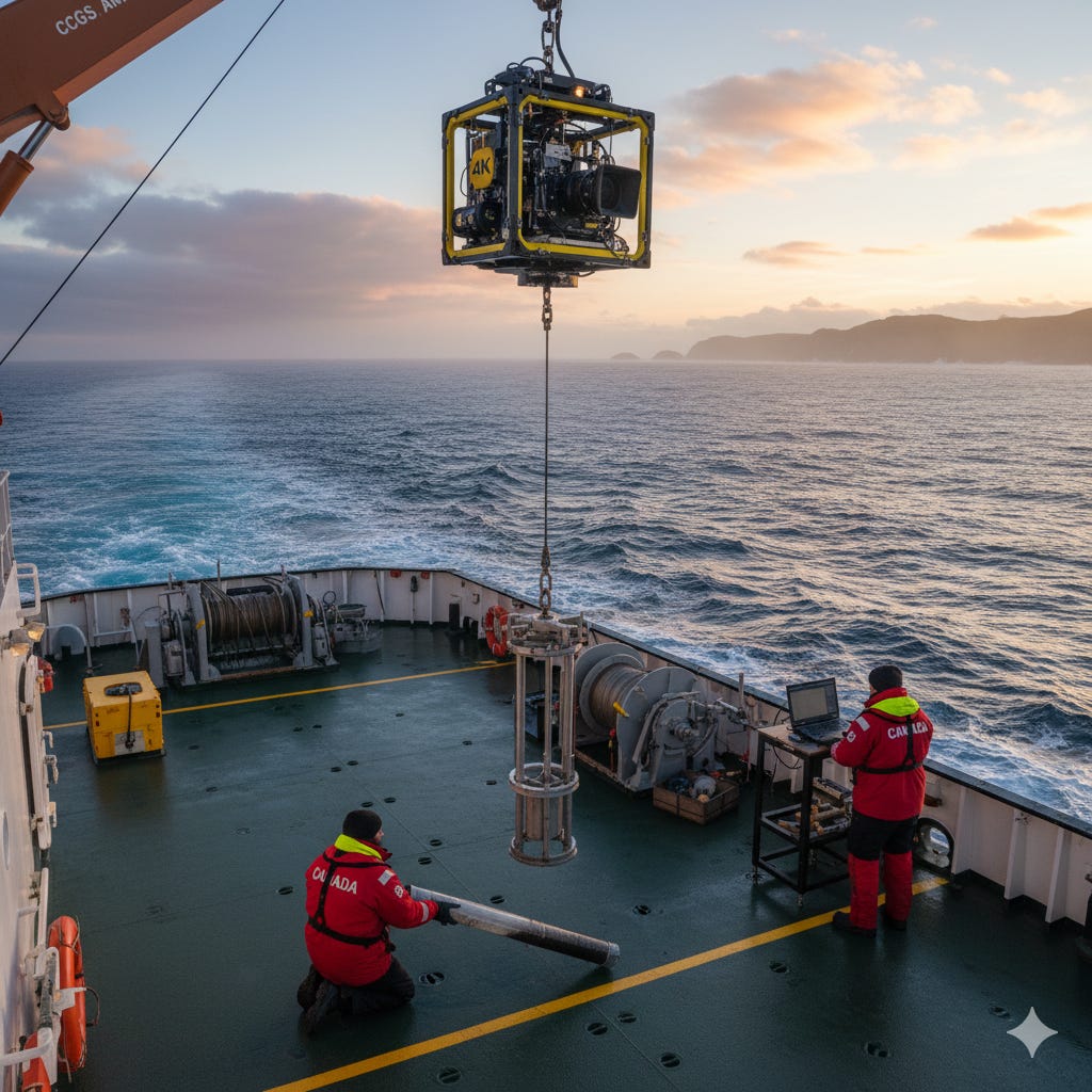
From August 14 to 24, 2020, the Amundsen became a floating laboratory. The team’s work was split into two modes. During the day, they stopped the ship at specific stations to sample the seafloor. At night, while transiting between stations, they mapped it.
To get a picture of the seabed and the layers just beneath it, they used sophisticated sonar systems. An EM-302 multibeam echosounder mapped the seafloor’s topography, ultimately covering 5,900 square kilometres of new territory. A Knudsen 3.5 kHz echo-sounder sent sound waves deeper into the sediment, revealing its sub-bottom stratigraphy, much like an ultrasound for the earth.
To physically sample the ocean floor, the team deployed several tools:
Piston and Gravity Corers: These devices are long, weighted tubes dropped into the seabed to extract deep columns of sediment. The team successfully collected 10 piston cores and 10 gravity cores, recovering a total of 56.36 metres of sediment. These samples provide a timeline of geological history, helping to date events like submarine landslides.
Box Corers and Grabs: To get a large, relatively undisturbed sample of the surface, the team used a box corer. For a quicker, representative sample, they used a Van Veen grab sampler.
4K Drop Camera: To see what the seabed actually looks like, the scientists lowered a custom-built 4K camera system. At 18 different stations, in water depths down to 2,300 metres, they captured 784 high-resolution photographs of the seafloor, revealing everything from bedrock outcrops to the animals living there.
The Findings: A First Look at the Seafloor
The expedition was a success, yielding a massive amount of new data. The preliminary results documented in the report already paint a clearer picture of this deep-sea environment.
The team confirmed that variability in their sonar data was related to the presence of coarse-grained sediment, including patches of well-rounded boulders and bedrock outcrops, even at depths over 2,000 metres. This suggests a history of upper-slope instability and sediment moving down-slope. They also found that conspicuous pockmarks, or depressions in the seafloor, contained gravel, possibly indicating that gas or liquid is actively seeping out and removing finer sediment. This theory was supported when an echosounder detected a possible gas flare over one of these features.
Perhaps most surprisingly, the seabed imagery showed only a moderate abundance of soft corals and a rare presence of hard corals. This is notable because the area is part of the Northeast Newfoundland Slope Closure, a marine conservation area established specifically to protect high-density populations of deep-sea corals and sponges. This finding highlights the importance of direct observation. Without these photographs, our understanding of the habitat would remain purely theoretical.
The Data Brief
The CCGS Amundsen 2020804 expedition was a mission to ground-truth previous remote-sensing surveys of the Northeast Newfoundland Slope. The goal was to provide data for marine spatial planning, hazard assessment, and habitat mapping. Over 10 days, the team collected 56.36 metres of sediment cores, 784 high-resolution seafloor photographs, and mapped 5,900 square kilometres of the seabed. Key preliminary findings include the presence of boulder fields and bedrock at extreme depths, evidence of possible gas seepage from pockmarks, and a lower-than-expected density of hard corals within a marine protected area.
Why This Matters
This expedition report is more than just a summary of scientific activity. It’s a window into the quiet, methodical work of governance. Managing a country with the world’s longest coastline requires a deep and precise understanding of its marine environments. Missions like this provide the foundational knowledge needed to make sound, long-term decisions about resource extraction, hazard mitigation, and conservation. It’s not glamorous work, but it is essential. The next time you think about Canada’s oceans, remember that our understanding of them is built one sediment core, one sonar ping, and one deep-sea photograph at a time.
Source Documents
Kostylev, V. E., Broom, L. M., Robertson, A. G., Carson, T. E., & Hayward, S. E. (2020). CCGS Amundsen 2020804 expedition: Seabed habitats and marine geohazards in the Northeast Newfoundland Slope, Labrador Sea (Geological Survey of Canada, Open File 8749). Natural Resources Canada.