

The Lake That Broke the Barrier
Inside the lab where scientists built a scale model to save a $50M wetland from Lake Erie.

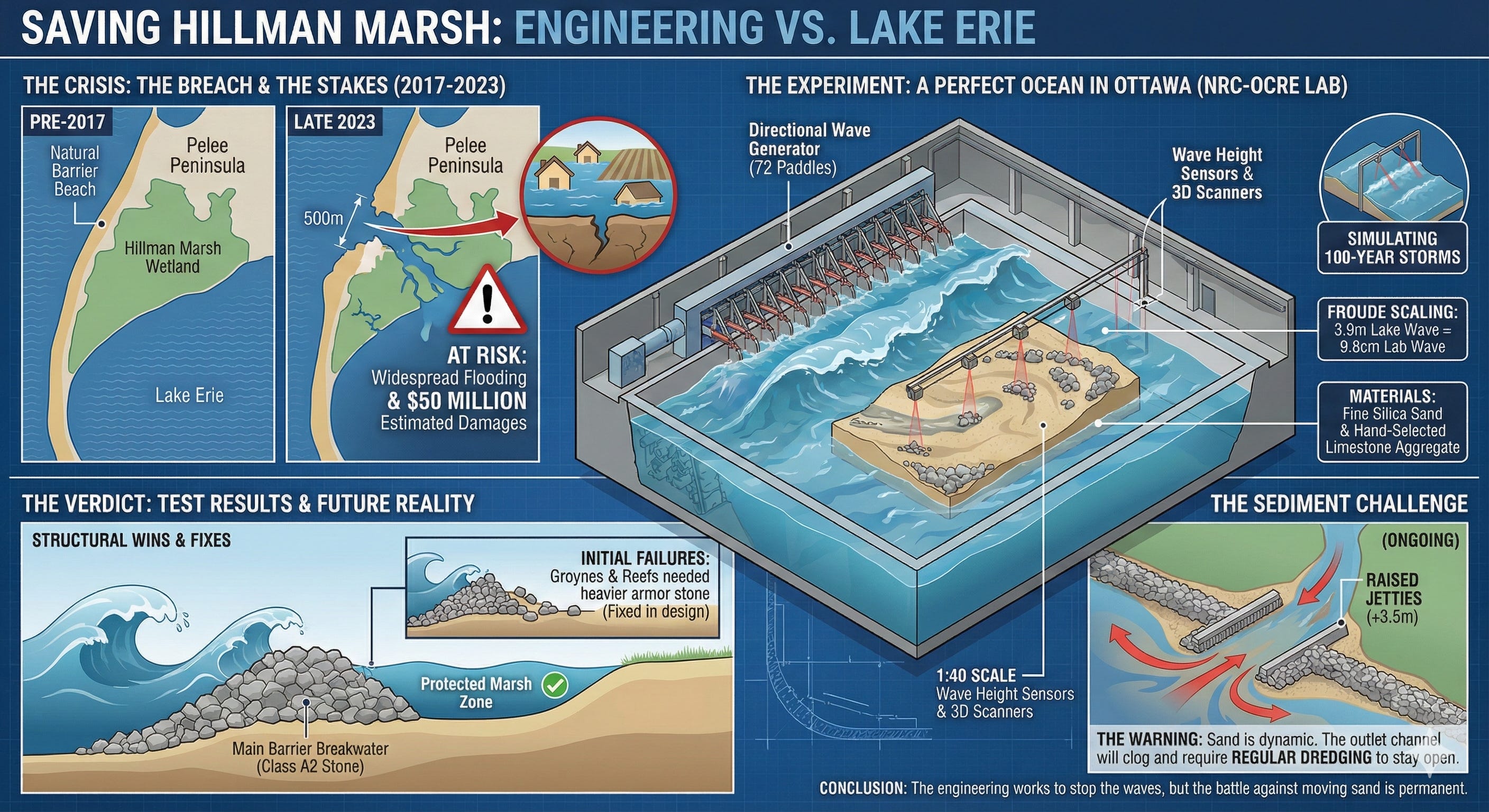
In the spring of 2017, Lake Erie changed its mind about the coastline of the Pelee Peninsula. For decades, a natural barrier beach had stood as the primary line of defense for the Hillman Marsh, a sprawling, provincially significant wetland in Leamington, Ontario. The barrier was a thin ribbon of sand and scrub that separated the violent, open waters of the lake from the quiet, protected ecosystem behind it. But in 2017, driven by record-high water levels and a deficit of sediment caused by human interference, the lake punched through.
The breach started small. It did not stay that way.
Over the next six years, the gap widened with terrifying speed. By late 2023, the breach spanned nearly 500 meters. The barrier beach was effectively gone, replaced by open water and a growing, unstable sand spit extending into the marsh. The consequences of this geomorphic collapse were immediate and severe. The Hillman Marsh, once a sanctuary for endangered aquatic species and migratory birds, was now exposed to the full kinetic energy of Lake Erie’s waves.
The stakes, however, extended far beyond ecology. The marsh is ringed by a system of earthen dykes constructed under the Drainage Act. Behind those dykes lie low-lying agricultural lands and residential properties. If the waves that destroyed the barrier beach were allowed to hammer the perimeter dykes unchecked, the resulting breach could trigger widespread flooding with economic damages estimated to exceed $50 million.
Faced with this slow-motion disaster, SJL Engineering commissioned a rescue plan. They proposed a complex restoration involving a new artificial barrier beach, submerged rock shoals, and strategic jetties. But before a single stone could be placed in the lake, the design had to be proven.
That proof would not come from the field, but from a massive, windowless facility in Ottawa. There, inside the Large Area Basin of the National Research Council’s Ocean, Coastal, and River Engineering Research Centre (NRC-OCRE), Senior Researcher Scott Baker and his team were tasked with building a copy of the coast. They constructed a 1:40 scale replica of the Hillman Marsh, complete with its bathymetry, its sediment, and its storms, to determine if the proposed fix could survive the worst Lake Erie had to offer.
A Perfect Ocean in Ottawa
The Large Area Basin is a cavernous indoor facility measuring 50 meters by 30 meters, capable of holding water depths up to 1.5 meters. It is a theater of hydrodynamics where engineers play god with the weather. For the Hillman Marsh project, the basin was outfitted with a state-of-the-art directional wave generator featuring 72 independent wave boards. These paddles, driven by complex algorithms, could synthesize realistic, short-crested sea states, replicating everything from a gentle summer swell to a catastrophic 100-year storm event.
Building the model was an exercise in rigorous precision. The underlying bathymetry—the shape of the lakebed—was constructed using a network of CNC-milled templates and concrete grout, accurate to within a few millimeters. This rigid bed represented the “future condition,” a scenario where the existing beach had fully collapsed, exposing the lake bottom to erosion.
The water used was fresh, just like the lake. But the physics of scaling a coastline down to the size of a hockey rink required careful compromises. In the world of hydrodynamics, gravity and inertia rule. The model was designed using Froude scaling, ensuring that the relationship between wave height, speed, and time remained physically consistent with the real world. A wave height of 3.9 meters in the lake became a manageable 9.8 centimeters in the tank. A storm lasting three hours in nature played out in just under 29 minutes in the lab.
The most difficult variable, however, was the ground itself. To simulate the beach, the NRC team used fine silica sand with a median diameter of 0.167 millimeters. Scaled up, this behaved similarly to the coarser sand found at Leamington. For the rock structures—the breakwaters, reefs, and groynes—the team hand-selected limestone aggregate, weighing individual stones to ensure they matched the density and stability of the massive armor stones proposed for the actual construction.
The stage was set. The goal was to subject this miniature coast to a gauntlet of 100 individual tests, measuring wave height, current velocity, and the catastrophic movement of stone and sand.
Armor Against the 100-Year Storm
The investigation began with a “worst-case” assumption. In the first phase of testing, known as Test Series 1 and 2, the researchers stripped the beach away entirely. They wanted to see how the hard infrastructure—the proposed barrier breakwater, the offshore reefs, and the jetties—would hold up if they were completely exposed to the lake without the cushioning effect of a sandy beach.
They installed a “limited mobility bed” of stone chips to replicate the roughness of the lake floor without allowing it to reshape significantly. Then, they turned on the wave machine.
The team ran simulations of annual storms, 10-year events, and finally, the dreaded 100-year storm combined with record high water levels. Sensors recorded the wave height at twenty different locations, while overhead cameras monitored the structures for damage.
The results were illuminating. The main barrier breakwater, a spine of rock designed to close the breach, performed exceptionally well. Even under the assault of the 100-year storm (designated sea state G92), the structure suffered only minor damage, with a few rocks displaced on the crest. More importantly, the barrier did its job. The wave sensors behind the wall, inside the protected marsh zone, registered calm waters. The energy of the lake had been broken.
However, not every structure survived unscathed. The north groyne, a perpendicular stone structure designed to trap sand, took a beating. During the high-intensity tests of Series 2, where the team experimented with smaller, cheaper armor stone (Class A3), the groyne suffered moderate damage. Stones were overturned and dragged away by the currents. The data was clear: the groyne needed heavier armor. The design was reverted to the more robust Class A2 stone for subsequent tests.
The offshore reefs, submerged piles of rock intended to break the waves before they hit the shore, also showed vulnerabilities. Stones were flipped and displaced, particularly on Reef 6 and the spur attached to the south headland. These failures were precisely what the client, SJL Engineering, needed to see. It is far cheaper to watch a rock wall fail in a water tank in Ottawa than to watch it collapse into Lake Erie during a November gale.
The Migration of the Sand
With the structural stability assessments complete, the team moved to Phase 2: the mobile bed tests. This was the heart of the experiment. The stone chip floor was removed and replaced with 9,500 kilograms of silica sand. The team carefully sculpted a new foreshore and a massive sand barrier burying the breakwater, replicating the proposed beach nourishment plan.
The question now was not just whether the rocks would hold, but where the sand would go. Sediment transport is notoriously difficult to model, as it relies on the complex interplay of grain size, wave energy, and nearshore currents. To track the movement, the researchers used a Faro 3D laser scanner to create high-resolution topographic maps of the beach before and after each test series. They also injected colored dye into the water to visualize the invisible rivers of current flowing beneath the waves.
The dye tests revealed a complex circulatory system. In some areas, the dye moved quickly northward; in others, it stagnated or was pulled offshore. But as the wave intensity increased to match the historical 100-year water levels, the scanner revealed a troubling trend.
The beach began to retreat.
Under the pounding of the G92 sea state, the shoreline in the first “cell”—the pocket of beach between the south headland and the first reef—receded significantly. The sand was pushed landward, washing over the top of the buried breakwater. While the rock core remained stable, the beach face itself was being reshaped by the energy of the water.
More concerning was the movement of sand near the outlet channel. This channel is the lifeline of the marsh, allowing water to flow between the wetland and the lake. The model showed sand migrating from both the north and south, forming large lobes that began to choke the channel. By the end of Test Series 3, the channel had narrowed by approximately 30 percent. The jetties, designed to keep the channel open, were being overrun.
The Final Stress Test
The final phase, Test Series 4, introduced the most complex variables yet. The team reshaped the sand to include the existing sand spit—the unstable finger of land currently extending into the marsh—and a “relic dyke” feature. This was the “post-construction” reality, incorporating the messiness of the actual site conditions.
They also modified the jetties. To combat the sand clogging observed in the previous tests, the crest elevation of the jetties was raised from +3.0 meters to +3.5 meters.
The wave generator roared to life, simulating the 100-year storm events with climate change allowances (Sea States H92 and I92). The results were dramatic. The existing sand spit, hammered by waves, was completely flattened. It receded landward by nearly 100 meters, eventually inundating the relic dyke with sand.
The increased jetty height helped, but it was not a silver bullet. Sand continued to wash over into the outlet channel, particularly from the south side. By the end of the testing, the channel was nearly completely choked off, the current meters buried in sediment.
Despite this, the primary objective was achieved. Throughout the entire battery of tests, wave transmission into the marsh remained negligible. The maximum significant wave height measured behind the barrier was only 0.20 meters, even when 3.9-meter waves were crashing against the outer defenses. The marsh remained calm. The flood risk to the interior dykes was effectively neutralized.
The Price of Protection
The physical modeling of the Hillman Marsh restoration offers a stark preview of the project’s future. The engineering works. The combination of offshore reefs and a hardened barrier beach successfully absorbs the kinetic fury of Lake Erie, protecting the fragile wetland and the valuable land behind it. The disaster of a breached perimeter dyke and the associated $50 million in damages can be prevented.
But the model also delivered a warning. The system is dynamic, not static. The sand will move. The beach will retreat during extreme high water events. The outlet channel will fight a constant battle against sedimentation, requiring regular maintenance and dredging to stay open.
The report concludes that the optimized structures—the bolstered groyne, the re-profiled breakwaters, and the raised jetties—are ready for the real world. The 1:40 scale simulation has done its job, revealing the weak points in plastic and plywood so they don’t have to be discovered in stone and failures.
As the water drained from the Large Area Basin for the final time, the silica sand lay reshaped in new, natural curves, dictated by the physics of the waves. It was a map of the future, drawn by water. The Hillman Marsh can be saved, but the lake will never stop testing the defenses.
Source Documents
Baker, S. (2025, November 6). Physical Modelling of the Hillman Marsh and Barrier Beach Restoration Project [Technical Report]. National Research Council Canada.