

The Quiet Competence of Arctic Navigation
How a Canadian-developed AI is solving the granular, real-world problem of operating in our most strategic waters.

When you hear politicians discuss the Arctic, the conversation often revolves around grand ideas like sovereignty, security, and the economic promise of the Northwest Passage. These are important, high-level debates. But they obscure a much more fundamental question: what does it actually take to operate a vessel safely and efficiently through the shifting, treacherous ice fields of our northern waters? The answer, it turns out, lies not in broad strategy, but in mastering the complex, second-by-second tactics of navigating a floating maze.
A new research paper, developed in part by Canada’s National Research Council, provides a revealing look at this challenge. It details a system that moves beyond the theoretical and into the practical, showing how true capability is built. The paper is technical, but its implications are strategic. It points to a critical gap in our public understanding of what it means to be an Arctic nation. We are focused on the satellite map, while the real work happens at street level.
The Flaw of Navigational Generalities
For years, the primary tool for ice navigation has been about finding the best global route. Using satellite data, planners map a path through areas with the lowest ice concentration. This approach is useful, but it’s like using a traffic app to plan a drive from Calgary to Vancouver. The app can tell you the best highway to take based on general conditions, but it cannot steer your car around a pothole, a patch of black ice, or a piece of debris that has fallen onto the road.
This is the core problem for ships in the Arctic. The dominant condition is not a solid sheet of ice, but what experts call “broken ice fields”. These are seas filled with a collection of discrete, floating ice floes of varying sizes and shapes. In these conditions, as the research makes clear, achieving a completely collision-free path is often impossible. A ship must make contact with the ice. The old model of simply avoiding dense areas becomes insufficient. This is where we must introduce a new concept, Navigational Granularity. This is the shift from high-level planning to low-level execution. It’s the difference between knowing which highway to take and having the skill to navigate the actual road surface, second by second.
The Physics of Smart Collisions
This is where the Canadian-developed framework, AUTO-IceNav, represents a fundamental change in thinking. Instead of trying to achieve the impossible goal of avoiding all collisions, it aims to intelligently manage the inevitable ones. The system’s objective is not to find a clear path, because one might not exist. Its objective is to find the path that causes the least amount of damage and wastes the least amount of energy.
The researchers built a novel cost function that calculates the kinetic energy a ship would lose from colliding with any given ice floe. The system doesn’t just see “ice.” It sees a field of obstacles, each with a specific cost. A head-on collision with a large, heavy floe represents a high cost in terms of potential damage and lost momentum. A glancing blow that pushes a smaller floe aside represents a much lower cost. AUTO-IceNav computes millions of potential paths and selects the one with the lowest total collision cost. It favors maneuvers that push ice aside rather than breaking through it, effectively finding the path of least resistance in a way no human operator could calculate in real time.
This approach is implemented through a clever two-stage process. First, a planner rapidly sketches out a good, feasible path through the ice field. Then, a second optimization-based step refines that path, smoothing it out and finding local improvements to produce a truly optimal route through the immediate environment. It’s a methodical and robust solution to a chaotic and dynamic problem.
From Theory to Tangible Results
The performance of AUTO-IceNav in extensive simulations is nothing short of remarkable. Compared to a strategy of simply powering straight through and another that seeks the shortest path through open water, the benefits are clear and measurable.
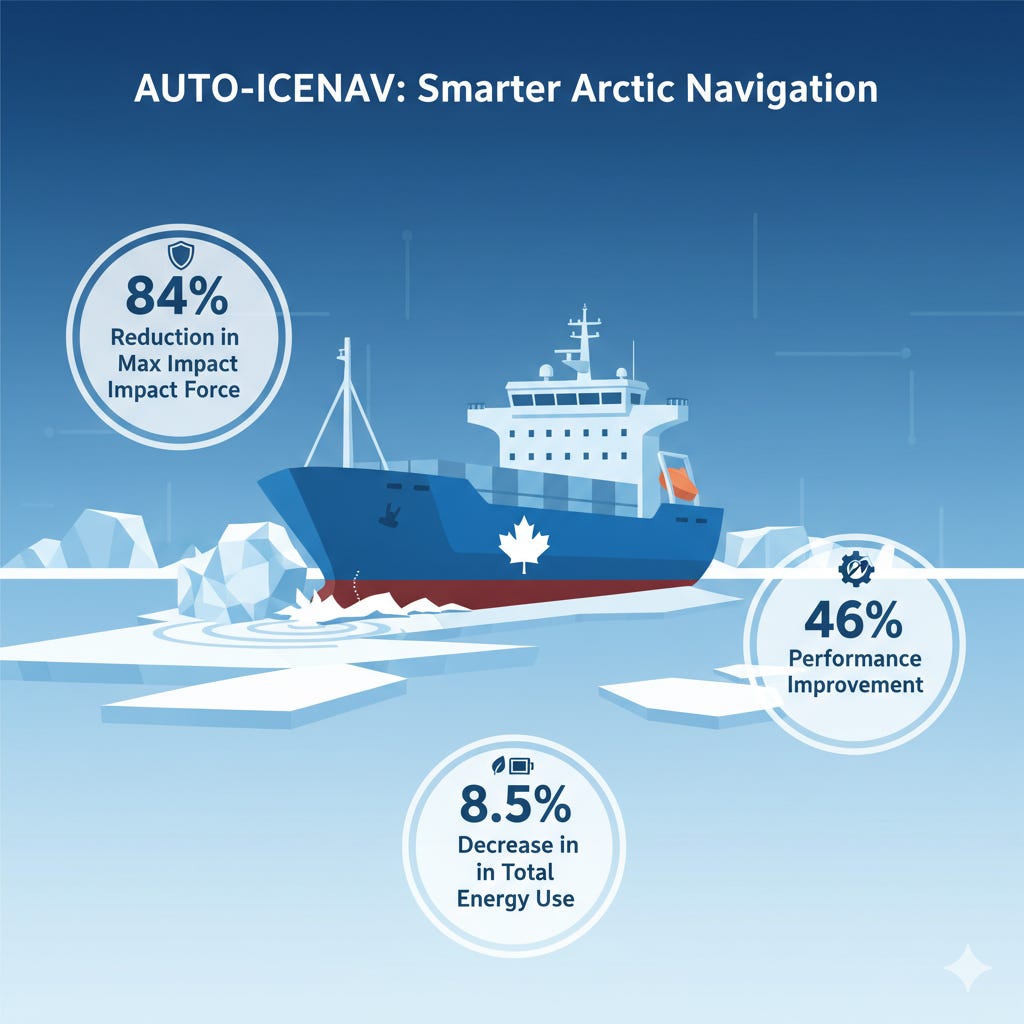
AUTO-IceNav reduced the mean impact force by 62% and the maximum impact force by 84% compared to the straight-line approach.
This is the detail I find most revealing. The reduction in maximum impact force is especially critical, as these are the events that cause structural damage to a ship’s hull, leading to costly repairs and taking a vessel out of service. Beyond safety, the system delivered a surprising economic benefit. By minimizing the kinetic energy lost to collisions, the ship operates more efficiently. The simulations showed that even though the paths chosen by AUTO-IceNav were slightly longer, the system produced a significant net gain. The study found it achieved a decrease of 8.5% in total energy use compared to the straight-ahead trials. It makes the vessel safer and cheaper to operate. These findings were further validated in physical experiments conducted in a model-scale test basin in St. John’s, Newfoundland and Labrador, demonstrating a 46% performance improvement over prior work.
The Principle of Operational Sovereignty
This research is more than just a step forward for autonomous shipping. It is a perfect example of a foundational principle of governance. True sovereignty is not merely declared, it is demonstrated through operational competence. Having the ability to consistently, safely, and efficiently operate in a challenging environment like the Arctic is a more powerful statement of control than any political proclamation. This work, supported by the National Research Council of Canada, is a quiet story of building that deep, practical capability. It provides the intellectual ammunition to shift your focus from the frustrating noise of high-level debate to the tangible proof of progress. The future of the North will not be secured by rhetoric, but by the quiet competence of those who solve its most granular problems.
Sources:
de Schaetzen, R., Botros, A., Zhong, N., Murrant, K., Gash, R., & Smith, S. L. (2025). AUTO-IceNav: a local navigation strategy for autonomous surface ships in broken ice fields. IEEE Transactions on Robotics, 1-20.