

Canada’s Forgotten 1791 Earthquake
A new analysis of a historic tremor reveals the challenges of reconstructing Canada’s seismic past and what it means for our future risk.

A recent Open File from the Geological Survey of Canada offers a deep dive into an event most Canadians have never heard of: the Charlevoix earthquake of December 6, 1791. At first glance, a report on a 230-year-old tremor might seem like a purely academic exercise. But it serves as a powerful case study in how we reconstruct our history from fragmented evidence. More importantly, it provides critical data for understanding the seismic risks that persist today in one of Canada’s most active earthquake zones. This isn’t just about the past, it’s about building a more resilient future.
A Quake Shrouded in History
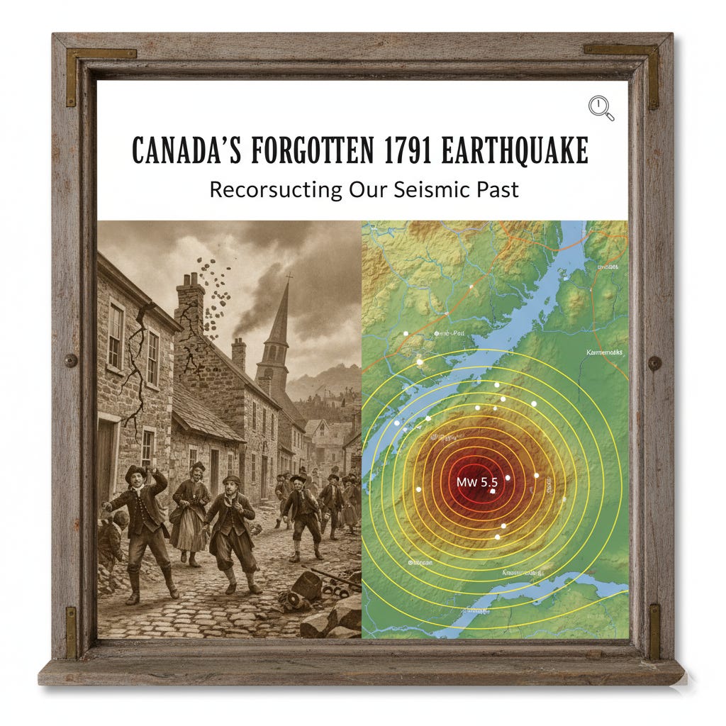
The main shock struck around 8:00 p.m. local time, centered near the St. Lawrence River in the Charlevoix Seismic Zone (CSZ). This region is the most active seismic zone in eastern Canada, having experienced at least five significant earthquakes of magnitude 5.5 or greater since 1663.
The 1791 event caused notable damage for its time. According to the few available accounts, communities like Baie-St-Paul, Île-aux-Coudres, and Kamouraska sustained the most harm. The damage was mostly confined to housewares and masonry chimneys, but some stone houses were cracked and the churches in Bas-des-Éboulements and Kamouraska were damaged. For weeks after, dozens of aftershocks kept residents on high alert.
The Detective Work of Seismology
So, how do you study an earthquake that happened long before modern seismographs? The analysis relies on what are called “macroseismic” reports, which are essentially historical felt accounts. Researchers combed through the limited sources of the era, including newspaper articles and letters, to piece together a picture of the earthquake’s impact.
The challenge, as the report makes clear, is the scarcity of information. In 1791, the population was sparse and newspapers were few. The earthquake was felt in Quebec City, but there were no reports of it being felt in Montreal, New England, or New Brunswick. This lack of widespread reporting is a critical clue, but also a major analytical constraint.
Using these historical accounts, seismologists rate the shaking at different locations using the Modified Mercalli Intensity (MMI) scale. This allows them to map the extent and severity of the tremor, which in turn helps estimate its magnitude and epicentre.
The Magnitude Puzzle
Estimating the magnitude of the 1791 quake presents a puzzle. Two key pieces of evidence seem to contradict each other.
On one hand, the damage in the epicentral region, like cracked stone walls and damaged churches, suggests a magnitude approaching 6.0. On the other hand, the relatively small felt area suggests a much weaker event. For comparison, more recent, instrumentally recorded earthquakes in the region with smaller magnitudes were felt over a much larger area, including in Montreal and New England.
What does this mean? The report’s author, M. Lamontagne, carefully weighs the evidence. He concludes that a moment magnitude ($M_w$) in the range of 5.3 to 5.5 is the most likely fit. An earthquake of this size would be strong enough to cause the documented local damage, especially to older masonry buildings on poor soil, yet weak enough to be barely noticeable at greater distances like Montreal. This careful reconciliation of conflicting data is a perfect example of the scientific process at work.
Why This Historical Quake Matters Today
Revisiting the 1791 earthquake is more than a historical curiosity. Understanding the frequency and magnitude of past seismic events is the foundation of modern hazard assessment. The Charlevoix Seismic Zone remains a region of significant risk. By creating a detailed digital repository of the 1791 event, including all available felt reports, researchers build a more complete picture of the region’s long-term seismic behaviour.
This data helps engineers design more resilient infrastructure and informs emergency preparedness planning. Each historical earthquake we re-analyze sharpens our understanding of what the future might hold, allowing us to better protect Canadian communities.
The Data Brief
The Event: The Charlevoix earthquake occurred on December 6, 1791, with an estimated moment magnitude ($M_w$) of 5.5.
The Epicentre: It was located in the Charlevoix Seismic Zone (CSZ) along the St. Lawrence River, the most active seismic zone in eastern Canada.
The Impact: The earthquake caused considerable damage to masonry chimneys and some buildings in Baie-St-Paul, Île-aux-Coudres, and Kamouraska.
The Analysis: The magnitude was determined by interpreting historical “macroseismic” information, balancing evidence of significant local damage against a surprisingly limited felt area.
The Implication: Studying historical earthquakes provides essential data for assessing modern seismic hazards and improving the resilience of Canadian infrastructure in high-risk zones.
Looking Back to See Ahead
Reconstructing a 230-year-old earthquake from sparse newspaper clippings and letters is a meticulous process, one that requires navigating ambiguity and conflicting evidence. This analysis of the 1791 Charlevoix quake shows that our understanding of history is never truly finished. It’s a living discipline, constantly refined by new evidence and better analytical tools. Ultimately, this work reminds us that looking into the past is one of the most effective ways to prepare for the future.
Source Documents
Lamontagne, M. (2020). The 1791 magnitude (Mw) 5.5 earthquake, Charlevoix, Quebec: interpretation of macroseismic information (Open File 8739). Geological Survey of Canada.